Eski-kermen
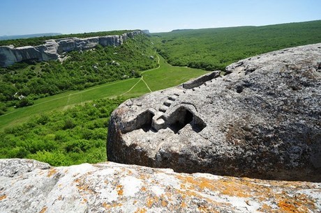
Eski-Kermen is one of the most picturesque cave towns. It is located in the south-western area of the mountainous region of the Crimea, 6 km to the south from Krasnyy Mak (Russian for "red poppy") village, on the plateau of a mesa, which stretched along the north-south axis. This plateau is 1,040 m long and maximum 170 m wide. Its north and east slopes had steep precipices rising up to 30 m high above neighboring valleys.
"Not far from Mankopia is a certain very ancient fortress and town, but it does not have any name from the Turks or Tatars, no even from the Greeks themselves, because of its extreme antiquity…", the Polish ambassador Martinus Broniovius (Martin Broniewski) wrote in the 16th century. It was probably the reason why the Tatars started to call it simply "Eski-Kermen", which meant "the old fortress".
The settlement, covering area of 8,5 hectares is situated on the plateu of the precipitous mesa. According to archeological sources the fortress was built at the close of the 6th century, on the initiative of Byzantine autohorities. Its garrison consisted of the goths and alans - the federates of the empire.
Eski was not only a fortress, but also a major center of trade, religion and commerce. Agriculture, however, was the basis of its economy. Fertile valleys were used to cultivate vines, vegetables and fruit.
Its powerful defense system with walls made from lime-stone blocks of 2m wide and 3,5m height, relatively well-developed economy and advantageous position made Eski-Kermen an important political and administrative center in South-Western Crimea, until the close of the VIIIth century, when an insurrection of the local populations in the mountains of the Crimea against the domination of the Khazars drastically changed the fate of the town. The Khazars suppressed the uprising and having no need for fortresses, they ruined the defense structures of Eski.
In the late 6th century, a Byzantine boundary fortress was established here and manned by a garrison of the Goths and Alans. This fortress received excellent fortifications. A road leading to the main town gate was cut into the bedrock on the gently sloping southern side of the mountain. Located near the main town gate southern defensive complex was especially fortified, the northern patrol complex was arranged on the opposite side of the plateau, and casemates and cells for guards were built along the edge above the precipices in order to control approaches to the fortress.
Simultaneously with the erection of the fortress, a siege well was constructed at the eastern precipice of the plateau. The architects cut this narrow corridor or tunnel into the depth of the bedrock that forms a steep staircase of 6 flights and 95 steps. Each flight finishes with a platform, one of which contains a through aperture to light the staircase. The tunnel ends with a 10-m-long gallery where water was collected from a natural spring. In course of the first flight, there was a special room for the guards who defended this strategic object.
This fortress kept strategic stocks of grain which were stored in large, carved in bedrock pits. The system of defense includes also the so-called northern patrol complex, which was placed on the northern extremity of the plateau, with a saddle dividing it from the main site. One could reach it through a special cave only, which had a disguised entrance and staircase of two flights that lead to a watch platform offering a fine observation post over the neighborhood. The first inhabitants and builders of the fortress, the Goths were Christians, so they were building cave churches and aboveground basilica simultaneously with the fortress.
In the 8th century, the fortress was occupied by the Khazars, who probably demolished the system of the fortress defense. From the late 10th to the 13th century, Eski-Kermen was a small town with rectangular living quarters and aboveground and cave churches. In the most high spot of the plateau stood the basilica, which was erected in the 6th century and collapsed, together with the whole town, in the late 14th century, under the Mongol khan Edigu's raid against the Crimea.
In the late 10th century the Byzantine dominion was restored. Since that time the medieval town had been gradually forming at Eski-Kermen. The town continued to exist until it was completely destroyed in 1299 by the hordes of Emir Nogai.
The ruins of the late medieval fortress of Kyz-Kule (Tatar for "tower of virgins"), which existed in the 14th and 15th centuries, preserved to the north-west of Eski-Kermen, on the hard-to-get plateau of the opposite side of the canyon. Picturesque ruins of a gatehouse, a small one-apse chapel with cut in rock tombs, and traces of buildings of still unknown purpose occupy the territory of this fortification.
Ascending road led from the valley to the Main Town Gate. The gateway was breached in the rock-mass. There are two cave-temples at the flight of the ascending road. They were built in the late 10th century - in the beginning of the 11th century. The cave-temple "Sudiliche" (The Trial) is situated on the right side to the rock corridor which leads from the Main Gate to the main street.
This is the biggest cave-temle in the town. There have been found 400 cave-structures in Eski-Kermen. Most of them were used for domestic needs, mainly, as cattle-sheds. Basilica is located on the highest plateau. it was built in the late 6th century, rebuilt in 8th century and considerably reconstructed in the 11th century. Siege Well was to supply water in case of the siege of the fortress. It was cut through the thickness of the rock from the upper plateau to the foot, whare the spring welled up.
In the neighbourhood of Eski-Kermen you can see many monuments of interest. These are ''Three Riders" (13th cent.) and "Donators' " (the 13th-14th cent.) cave-temples, Northern Watch Complex, Kiz-Kule fortification. You can get there by direct flight to Simferopol or through Kiev or Odessa.


